Tuesday, August 19, 2008
DON'T MISS...
Monday, August 18, 2008
This Is What I Came Here To Do

The rising sun and clouds above made for some really interesting light conditions.
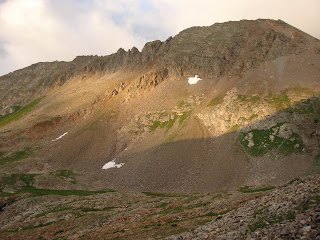

We still had a ways to go before we reached the basin where we could see the peaks we planned to summit. There was alot of evidence of mining in the area, but I didn't get any pictures of it. Once we reached the basin we had to cross a snow field and then do some lite bouldering on the talus to the left.

After navigating a bunch of loose rock we reached the summit ridge and made our final ascent to the summit. Some of the trail was pretty exposed, but the rock was solid. This picture is pretty deceiving, but it actually looks almost straight down. Hope you don't have vertigo!

You could see Conundrum Peak across the amphitheater. All that snow and the lake are actually on top of a glacier that is slowly melting. It is causing a crevasse that you can see around the lake. A hiker actually fell in the 30-foot-deep crevasse a few weeks ago before some of the snow melted. He was fine, but it was a little freaky.


We stayed for about an hour eating, drinking water, taking pictures, and trying to decide if we should hike over to Conundrum. The clouds were coming in waves and it was hard to see some of the trail. You can see most of the ridge up to the summit of Conundrum in this shot. The peak is actually to the right of the couliour hiding in the clouds. We saw one group climb up the couliour.

The clouds slowly lightened and we decided to make the traverse over to Conundrum. It only took us 45 minutes and we beat the group that was climbing up the couliour. They reached the top just as we were about to leave. You could look across and see part of the ridge that leads to Castle Peak. There were alot of people making their way up it. It looked like a trail of ants.

Here's me on the summit of Conundrum Peak. I'm so punny.

The hike down was by far the best part. We glisaded (slide on your ass in the snow and stop yourself with trekking poles/ice axe) most of the way down to the basin. The first part was the scariest because it led right to the crevasse and the lake below. If you carried too much speed, it would be hard to stop yourself and there wouldn't be a happy ending. I was a bit nervous since it was my first attempt at glisading. I stopped a bit lower than I wanted to, but well above the crevasse. We then traversed over to the left where you can see the biggest part of the crevasse in the picture above. We walked most of the way at the edge of the snow along the rocks. Eventually we had to cross another snowfield that was just above the big crevasse. I started making my way across but lost my footing and started flying towards the crevasse. I used my poles to slow down, but nothing happened. I realized that I QUICKLY needed to try something different and rolled over to my stomach. I got up on my knees and elbows and dug the poles in as hard as I could. I came to an abrupt and much welcomed stop. I carefully kicked footholds in the snow to make my way to the next rock pile. We had about another 700 feet that we got to glisade down from there and it was much easier and less dangerous.
Thursday, August 14, 2008
Training for the Big Ride
Yesterday I rode up Vail Pass at lunch for the first time in over a month. My time was about the same as usual and I felt great after the ride. I even went for a fast-paced 2.4 mile jog last night when I got home. I was pretty excited about the jog because it was the first time in over a year that I felt like I could lengthen my stride. Two things determine your speed: cadence (how often your feet hit the ground) and stride length (how far your foot travels between each hit). Not sure why my stride was suffering. Maybe tight hip flexors and IT bands?
Wednesday, August 13, 2008
Just Blogging
- Signed up on facebook and have wasted alot of time searching for long lost friends
- Researched the latest in waterproof-breathable gear, especially for hiking boots
- Read all my usual blogs
- Rode my road bike to the fire station towards the top of Beaver Creek
- Sat in the hot tub
- Watched the olympics
- Helped my friend start his first batch of homebrew
- Made sure I was up to date on all my bills
- Got the oil changed on my car (I had put that off for WAY too long)
- Changed my flight to Austin in September so I get there earlier and leave later
That's something I can write about. Just a gentle warning to anyone who plans to travel soon. Make sure to check-in online as soon as you can. With the airlines hurting, they are starting to overbook their flights. So even if you pay full price for your flight, you may find that when you get to the airport to check in, you are flying stand-by because everyone else has already checked in.
Plus, I had my flight booked for several months and I got a call the other day saying they have cancelled it and I could either reschedule at a different time or get a full refund. Isn't that nice of them. I plan ahead so I can get a cheap flight and then they say they will refund my money so I can try to find another flight that will be twice as expensive. I guess it actually worked out in my favor because I booked a flight that leaves a day earlier and returns a day later. Good thing I have enough vacation time.
Monday, August 11, 2008
Mt. Princeton
Came home and the forecast was slightly more favorable for Sunday, so we went for it. I arranged to meet with two other guys in Buena Vista and check out the trailhead. There is a road you can drive up from the main trailhead that takes off 3 miles each way from the hike. It is rated as a 4WD road and I only have a 2WD with high clearance, so we weren't sure how my car would handle it. My friend told me I should be fine, so we went for it in my Pathfinder. The steep cliff on the side of the road didn't bother me... because it was dark and I couldn't see how steep it really was. The road itself wasn't that bad as long as I took it slow and stayed out of the easily-avoidable ruts. Once we got safely to our destination we hit the trail at about 5:40 a.m. The sun was just coming up as we hiked up the fire access road. We got some good views of the sun rising over the south side of the Mosquito Range.


We continued hiking on the relatively easy trail. As we gained the ridge to the saddle, the clouds really started to settle in. They covered a large area, but weren't very dark (not holdig rain) and didn't seem to be building up (creates lightning). The thin cloud cover made for a pretty cool view.

After some trail finding and steeper climbing, we gained the summit. Just in time for it to start sleeting on us. We snapped a few quick pictures, put on rain gear, and started back down.


The hike down was pretty uneventful as we exchanged stories and quoted Family Guy. Drove back to Buena Vista and stopped for gas. There was a stand at the corner of the gas station so I decided to see what they were selling. The guy asked me if I'd ever had a Palisade Peach and cut me a juicy slice of paradise. I bought 1/2 a peck of the delicious delights. Headed back towards Leadville with my new bearded hiking partner, Chris (not to be confused with my roommate Chris), and went through my usual routine. Espresso at Provin' Grounds and hamburger and homebrew at Rosie's. I'm going to have to change up the espresso routine somehow because they ALWAYS burn the crap out of it. I end up pouring a bunch of sugar in it which is just not right. The rest of the drive home was nice with puffy clouds veiling some of the mountains.