Don't ask why I am posting this at 2 a.m. on a Saturday night, just laugh.
Sunday, August 31, 2008
Friday, August 29, 2008
More Glisading Video...
...or ass gliding, as my uncle calls it. This was the one that I actually lost my glisading cherry on. Notice how I don't stop when advised to do so. Still, I was well above the crevasse and lake below. It is the crevasse over to the left that was more intimidating.
Subway
I eat Subway too much. Probably because it is the only thing close that doesn't cost $8 (usually more) for lunch. Since they started the scrabble game I haven't won a damn thing... until today. I got a free cookie! Things are looking up.
Odd Feeling - Call It Intuition
Do you ever get a feeling from someone that there is something not right about them? Like they put on a facade but just under the surface is the terrible truth? Animals and little kids seem to have a keen grasp of this ability. You know how your dog growls at your neighbor for no apparent reason and you later find out that they are some rapist or child molester? Every once in a while I get that feeling about someone.
For instance, there is a guy who works in the office below me that I have always had a weird feeling about. He just seems overly friendly but lacks sincerity. I had an odd dream a few weeks ago and he was in it. I don't remember all the details, but it involved him driving around in a truck in what appeared to be the neighborhood where I grew up. He was going on a rampage and running into cars, mailboxes, and houses. I don't remember much more but it just reinforced my suspicions of him. I'm sure my pre-existing weariness of him contributed to the dream. Anyway, now when I see him or talk to him it seems like he is aware that I know he is a bad person. He kinda freaks me out. Hopefully I'm wrong, but none the less, I'll keep my distance.
For instance, there is a guy who works in the office below me that I have always had a weird feeling about. He just seems overly friendly but lacks sincerity. I had an odd dream a few weeks ago and he was in it. I don't remember all the details, but it involved him driving around in a truck in what appeared to be the neighborhood where I grew up. He was going on a rampage and running into cars, mailboxes, and houses. I don't remember much more but it just reinforced my suspicions of him. I'm sure my pre-existing weariness of him contributed to the dream. Anyway, now when I see him or talk to him it seems like he is aware that I know he is a bad person. He kinda freaks me out. Hopefully I'm wrong, but none the less, I'll keep my distance.
Thursday, August 28, 2008
Excited About Austin
Even though it is about a month away, I can't wait to visit Austin in September. I've been feeling a bit unsettled in Vail because I have been faced with the inevitability that I will be moving back to Austin... and I'm actually REALLY looking forward to it. I moved to a place where I can do all the activities I could ever dream of, my job gives me decent flexibility to do some of them during the work day, and I don't really have any responsibilities. But my life here just doesn't seem to be fulfilling without the people that I care about the most.
I never realized how great the group of friends are that I have in Austin. Well, I did, but I didn't realize how hard it would be to leave them. I have met good people out here, but nothing compares to family.
I never realized how great the group of friends are that I have in Austin. Well, I did, but I didn't realize how hard it would be to leave them. I have met good people out here, but nothing compares to family.
Wednesday, August 27, 2008
Mount Massive and Missouri Mountain
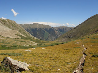
Yet another weekend has passed in my quest of summer hiking adventures. I started off by driving to the trailhead for Mount Massive early on Saturday morning. I hadn't decided if I was going to hike the standard 13.75 mile route or attempt driving up the 4WD road to take on the shorter 8 mile route. Once I arrived at the trailhead for the longer route, I quickly realized that I would be walking amongst a huge crowd if I took the standard route. So I decided to check out the 4WD road and hope I could make it up. I had read some reports that the first 2 miles weren't bad, but the last .5 mile could get pretty nasty. I have a Pathfinder with high clearance, but no 4WD. The reports were right, and I easily made it to the junction just before the road was supposed to get really rough. I bailed out and got my pack and gear ready. But before I took off I decided to walk up a bit to see what the road really looked like. It didn't look too bad, so I took it on. The road was rocky and bumpy, but nothing my car couldn't handle with good route choices. I finally came to one section where I wasn't as adept at chosing my line and spun my tires out as I tried to scale the rocky ditch. The stinch of burnt rubber persuaded me to back down the hill and park along the side. It wasn't worth risking injury to my car to save a quarter mile on a hike. After I walked back up the hill, I saw that I easily could have passed the section if I had driven a bit further to the left. Only problem was that I had a small margin of error for how far left I could drive. I really wasn't ready to barrel roll down a slope into a ravine. So I'm fine with hiking an extra 2 minutes. The rest of the road was pretty lame and flat all the way to the official trailhead. Here's the ditch that made me bail on my drive. Quit laughing at me. It's worse than it looks, especially before the sun comes up.

I started off at the official trailhead at 6:40 and decided I needed to get a move on. I quickly passed two groups and came to a clearing in the woods. Most of the peaks I could see were shrouded in clouds as the sun was poking it's head out.

This is the same peak just a few minutes later after the sun had burnt the clouds off.

I hiked up above treeline through some switchbacks and found a horse on the trail in front of me. I had to stop for a picture op. (If you don't get the horse reference, click here and watch the video.)

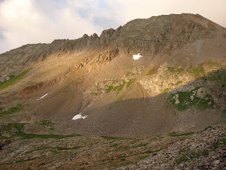
I summitted in about 3 hours and there was already a crowd on top from the standard route. After eating a bit of pasta I remembered some advice from a friend of mine. Apparently it was pretty easy to traverse to North Massive, so I decided to go for it (with no further knowledge than "there is the next peak"). The sky's were clear, I had plenty of energy, and I didn't feel like being surrounded by the crowd. North Massive can be seen as the highest peak in the distance. Most of the traverse on the ridge looked easy, but I wasn't sure about the last section leading to the peak.

These look back to the right of the route I took up from the top of Mt. Massive. You can see both of the Halfmoon Lakes in the second shot.


Off I go to conquer the trail to North Massive. Since I wasn't sure of the route, I decided that I would turn around if I lost the trail or got into any really sketchy territory. The first part of the route was easy as long as I kept my eyes open on the trail ahead. The trail dissipated as I approached the peak and got into some bigger rocks. I had to hunt for cairns that marked the way instead. I had my eye on the face of North Massive for the whole hike. It was looking steeper and steeper with no apparent trail. Eventually I came to the section I was dreading. The mountain was steep with lots of loose rock lying around huge sturdy boulders. After studying the route I decided to slowly ascend to just below the ridge and then scramble to the saddle before the peak. I noticed a guy waving at me from the summit which eased my nerves. At least if I fell he would likely hear me and could call Search and Rescue. The section I went up would be easy by my usual climbing standards... when I have a climbing partner, climbing shoes, and a ROPE! I was very careful to make sure each rock I grabbed or put my foot on was sturdy before moving any weight on it. It was pretty slow going, but I'd rather be slow than dead. I finally made it to the saddle. I think it was the first time I exhaled in about 10 minutes. This is the area I had scrambled across. I started the sketchy part from about the boulder on the far right of the picture and made my way across a small gulley and above the spire in the middle of the picture.

Once I got to the top I realized that the trail actually went on the other side of the mountain from the hard section I crossed. Oh well, I arrived safely and more confident of my climbing skills. Two other guys had just reached the summit and were about to make the traverse over to Massive. I advised them to stick to the left and avoid the section I crossed. That trail must have been REALLY easy because they were on the other side in about 2 minutes. I met a guy on the summit and we talked for a few minutes. He asked if I planned to hike to Point 14,001 for the full traverse and I decided I might as well. The clouds were barely gathering and not threatening. He also showed me another route down so I didn't have to traverse all the way back to Massive before descending. Here is the traverse back to Massive that I avoided. You can see Mt. Elbert to the right in the distance.

He took off for Point 14,001 as I finished changing my socks and eating some more pasta. I caught up to him after descending a scree field and we hiked the rest of the way out together. It started thundering and we got some thick, heavy, wet snow. It was time to really move so we could get to treeline.
Kevin (the guy I met) actually knows alot of the other people I have met in the Vail Valley that climb 14ers. We enjoyed a beer at our cars and I headed to town for some food. I started getting a really intense headache as I drove out. This looks back at Mount Massive. The main peak is towards the middle and North Massive is the sharkstooth point on the far right.

Once back in Leadville, I parked in front of Rosie's and my headache was still pounding. I leaned my seat back and ended up passing out for an hour. After a much deserved burger and beer, I made my way towards the trailhead for Missouri Mountain.
I found a spot to park and set up my tent. Only I never set up my tent because I passed out in the back of my car at 6 p.m. and slept through the night. I love sleep! After the great night of much needed sleep, I hit the trail around 5 a.m. on Sunday. It was the same steep switchbacks we hiked when we went up Belford and Oxford. I got a glimpse of the sunrise through the forest every once in a while.

Just before treeline I passed the abandoned cabin. I can't believe someone actually had a HOUSE this far up in the mountains. The mountain men and miners of times past put us to shame.

Just out of the forest I got my first glimpse of Missouri Mountain for the day. A thin strip of the peak and the ridge leading to it was lit up by the rising sun.

Most of this hike was the same as the trail for Belford and Oxford, so I trucked along pretty fast. The only group I saw on my trail was pretty far ahead, but I was determined to catch up with them and beat them to the summit. I finally passed them on the ridge that led to the summit. This was shortly before the only hard part of the hike. There is a section you have to climb down and then leads to a part that is steep with really loose dirt. I carefully passed this part and made my way to the summit. You can see the part you have to climb down in the pic on the left with the shadows. Mount Elbert is off in the distance to the right.

I didn't stay on top very long because I was ready to get a beer at my car. I passed over 25 people on my way down, so I was glad that I started early and hiked fast. The little guys below were all over the trail. They had some really cool shades of green and red. These two were the most barbaric. The one on the bottom was fodder for his feasting friends.

The hike down through the basin was pretty.
I passed several people who were all curious about what the trail ahead held for them. I was glad to take a break and doll out advice on my way down to my celebration beer.
A bit behind
Sorry I haven't updated in a few days. I'm usually too lazy to post on Mondays and I was in a class all day yesterday learning how to be more productive and efficient in Excel. After my lunch ride I will do my best to post a report of my trip from the weekend. Here's some of what you can expect:
- pictures (of course)
- a reference to a horse
- death-defying climbing on steep rock
- cannibalism
Interested? Thought so. Just wait until I get back from lunch.
Friday, August 22, 2008
Food Craving
I woke up this morning and for some odd reason thought a corny dog sounded good. (Yes, I said "corny" dog and not "corn" dog. That's how I roll). I can't even remember the last time I had one. Maybe what I really miss is good corn bread. I haven't had that in awhile either... no, I wanted a corny dog.

Thursday, August 21, 2008
Favorite Drink
I have a new favorite drink (for now). I'm sure once the weather changes and it starts getting cold I'll get back into scotch, scotch, scotch, I love scotch. Bombay Sapphire Gin, Tonic, and 1/4 of a fresh Palisade Peach (with juices squeezes liberally in drink). The magazine and lobster-cracking things have nothing to do with the drink. This was just the best picture I took of my new concoction.

Wednesday, August 20, 2008
Weird egg

Weekend Plans
I hope to hike/climb 2 or more of the following peaks this weekend:
- Antero
- Missouri
- Massive
- Harvard
Right now I am 2 peaks behind schedule, which actually puts me right on schedule considering that I scheduled to have extra room in my schedule.
StatCounter
I added a counter so I can see how many people visit the site. I don't completely understand how it works, but it should be interesting. I'm trying to set it so anyone can view the stats, but I'm having issues viewing the stats myself. We'll see.
Tuesday, August 19, 2008
DON'T MISS...
...the post before the bike video. I started it before and just finished it, but it still posted it lower. Whatever, just scroll down.
Monday, August 18, 2008
This Is What I Came Here To Do
Interesting weekend... it poured and stormed and huffed and puffed and tried to blow my house down. So I canceled my plans to hike on Saturday. And the group I was going to hike with on Sunday wimped out and decided to cancel our moonlight hike of Antero. But I wasn't ready to give up. We checked the weather and found that the forecast wasn't nearly as bad in the Elk Range. Even though it isn't part of the Sawatch Range that I want to finish this summer, I wanted to get out and hike. So we decided to hike Castle Peak and Conundrum Peak. Waking up at 1:30 a.m. is really not fun if you didn't get to sleep until 10 or 11. It rained for most of the drive to Aspen, but thinned out as we got closer to the trailhead. Once we started hiking, we got some snow flurries. Snow in August?!?!?!?!?! This is a shot down the valley we had just hiked up. We started just below treeline at 6:15 a.m.


We stayed for about an hour eating, drinking water, taking pictures, and trying to decide if we should hike over to Conundrum. The clouds were coming in waves and it was hard to see some of the trail. You can see most of the ridge up to the summit of Conundrum in this shot. The peak is actually to the right of the couliour hiding in the clouds. We saw one group climb up the couliour.
The rising sun and clouds above made for some really interesting light conditions.

We still had a ways to go before we reached the basin where we could see the peaks we planned to summit. There was alot of evidence of mining in the area, but I didn't get any pictures of it. Once we reached the basin we had to cross a snow field and then do some lite bouldering on the talus to the left.

After navigating a bunch of loose rock we reached the summit ridge and made our final ascent to the summit. Some of the trail was pretty exposed, but the rock was solid. This picture is pretty deceiving, but it actually looks almost straight down. Hope you don't have vertigo!

You could see Conundrum Peak across the amphitheater. All that snow and the lake are actually on top of a glacier that is slowly melting. It is causing a crevasse that you can see around the lake. A hiker actually fell in the 30-foot-deep crevasse a few weeks ago before some of the snow melted. He was fine, but it was a little freaky.

We pushed on and finally summitted at 9:00 a.m. (the first group of the day) in the windy, cloudy cold.

We stayed for about an hour eating, drinking water, taking pictures, and trying to decide if we should hike over to Conundrum. The clouds were coming in waves and it was hard to see some of the trail. You can see most of the ridge up to the summit of Conundrum in this shot. The peak is actually to the right of the couliour hiding in the clouds. We saw one group climb up the couliour.

The clouds slowly lightened and we decided to make the traverse over to Conundrum. It only took us 45 minutes and we beat the group that was climbing up the couliour. They reached the top just as we were about to leave. You could look across and see part of the ridge that leads to Castle Peak. There were alot of people making their way up it. It looked like a trail of ants.

Here's me on the summit of Conundrum Peak. I'm so punny.

The hike down was by far the best part. We glisaded (slide on your ass in the snow and stop yourself with trekking poles/ice axe) most of the way down to the basin. The first part was the scariest because it led right to the crevasse and the lake below. If you carried too much speed, it would be hard to stop yourself and there wouldn't be a happy ending. I was a bit nervous since it was my first attempt at glisading. I stopped a bit lower than I wanted to, but well above the crevasse. We then traversed over to the left where you can see the biggest part of the crevasse in the picture above. We walked most of the way at the edge of the snow along the rocks. Eventually we had to cross another snowfield that was just above the big crevasse. I started making my way across but lost my footing and started flying towards the crevasse. I used my poles to slow down, but nothing happened. I realized that I QUICKLY needed to try something different and rolled over to my stomach. I got up on my knees and elbows and dug the poles in as hard as I could. I came to an abrupt and much welcomed stop. I carefully kicked footholds in the snow to make my way to the next rock pile. We had about another 700 feet that we got to glisade down from there and it was much easier and less dangerous.
A fun experience for sure. I felt like a little kid. Now I can't wait for the snow to come. I plan to build an igloo this winter and sleep in it for a few nights. AWESOME!
Thursday, August 14, 2008
Training for the Big Ride
I realized it is time to start training for the Buffalo Bicycle Classic that I am riding on September 7th. I've never done an actual century ride (100 miles), but I've come pretty close. I did the MS 150 several years ago. It was from San Antonio to Corpus Christi, riding 90 miles the first day and 60 miles the second day. I also did the Shiner G.A.S.P. about a year ago which was 85 miles from Austin to the Shiner brewery. Still, neither count as an actual century ride.
Yesterday I rode up Vail Pass at lunch for the first time in over a month. My time was about the same as usual and I felt great after the ride. I even went for a fast-paced 2.4 mile jog last night when I got home. I was pretty excited about the jog because it was the first time in over a year that I felt like I could lengthen my stride. Two things determine your speed: cadence (how often your feet hit the ground) and stride length (how far your foot travels between each hit). Not sure why my stride was suffering. Maybe tight hip flexors and IT bands?
Yesterday I rode up Vail Pass at lunch for the first time in over a month. My time was about the same as usual and I felt great after the ride. I even went for a fast-paced 2.4 mile jog last night when I got home. I was pretty excited about the jog because it was the first time in over a year that I felt like I could lengthen my stride. Two things determine your speed: cadence (how often your feet hit the ground) and stride length (how far your foot travels between each hit). Not sure why my stride was suffering. Maybe tight hip flexors and IT bands?
Wednesday, August 13, 2008
Just Blogging
I don't really have anything interesting to say today, not that I am usually insightful or anything. Instead I am going to list some things that I have done lately.
- Signed up on facebook and have wasted alot of time searching for long lost friends
- Researched the latest in waterproof-breathable gear, especially for hiking boots
- Read all my usual blogs
- Rode my road bike to the fire station towards the top of Beaver Creek
- Sat in the hot tub
- Watched the olympics
- Helped my friend start his first batch of homebrew
- Made sure I was up to date on all my bills
- Got the oil changed on my car (I had put that off for WAY too long)
- Changed my flight to Austin in September so I get there earlier and leave later
That's something I can write about. Just a gentle warning to anyone who plans to travel soon. Make sure to check-in online as soon as you can. With the airlines hurting, they are starting to overbook their flights. So even if you pay full price for your flight, you may find that when you get to the airport to check in, you are flying stand-by because everyone else has already checked in.
Plus, I had my flight booked for several months and I got a call the other day saying they have cancelled it and I could either reschedule at a different time or get a full refund. Isn't that nice of them. I plan ahead so I can get a cheap flight and then they say they will refund my money so I can try to find another flight that will be twice as expensive. I guess it actually worked out in my favor because I booked a flight that leaves a day earlier and returns a day later. Good thing I have enough vacation time.
Monday, August 11, 2008
Mt. Princeton
My motivation to hike only partially waned this weekend. I began to lose motivation at the start of last week, and it continued with the nasty weather. The forecast called for a 50-60% chance of showers and thunderstorms for the weekend, including heavy showers. Every time I checked NOAA it seemed to get worse. I had tentative plans with some guys I met on 14ers.com to hike Harvard on Saturday and then to camp and hike Princeton on Sunday. We ended up canceling the hike up Harvard by Friday evening due to the threat of bad weather. So I went to dinner with Chris at a lovely (sarcasm) little restaurant called Los Amigos. We sat outside next to a bar cart that smelled like stale hagfish or something else that evokes vomiting sensations. The food was ok, but nothing comes close to REAL Tex-Mex. Slept late on Saturday (ahhhhhhh), went for a jog, then to Leadville for lunch at... wait for it... Rosie's Brewpub with Chris. We both wanted to get out of the area and he hadn't been to Leadville.
Came home and the forecast was slightly more favorable for Sunday, so we went for it. I arranged to meet with two other guys in Buena Vista and check out the trailhead. There is a road you can drive up from the main trailhead that takes off 3 miles each way from the hike. It is rated as a 4WD road and I only have a 2WD with high clearance, so we weren't sure how my car would handle it. My friend told me I should be fine, so we went for it in my Pathfinder. The steep cliff on the side of the road didn't bother me... because it was dark and I couldn't see how steep it really was. The road itself wasn't that bad as long as I took it slow and stayed out of the easily-avoidable ruts. Once we got safely to our destination we hit the trail at about 5:40 a.m. The sun was just coming up as we hiked up the fire access road. We got some good views of the sun rising over the south side of the Mosquito Range.


Came home and the forecast was slightly more favorable for Sunday, so we went for it. I arranged to meet with two other guys in Buena Vista and check out the trailhead. There is a road you can drive up from the main trailhead that takes off 3 miles each way from the hike. It is rated as a 4WD road and I only have a 2WD with high clearance, so we weren't sure how my car would handle it. My friend told me I should be fine, so we went for it in my Pathfinder. The steep cliff on the side of the road didn't bother me... because it was dark and I couldn't see how steep it really was. The road itself wasn't that bad as long as I took it slow and stayed out of the easily-avoidable ruts. Once we got safely to our destination we hit the trail at about 5:40 a.m. The sun was just coming up as we hiked up the fire access road. We got some good views of the sun rising over the south side of the Mosquito Range.
The sun was like a red balloon as it shot up from the mountains through the clouds.
As we approached the turn-off to get on the trail, the sun was casting an erie red glow on the trees and Unnamed Peak in front of us. Yes, it is actually named Unnamed Peak. One of the guys I was hiking with brought up an old sailors quote, "Red sky at night, sailors delight. Red sky in the morning, sailors take warning." At least we pretty much knew what to expect from the weather. And we weren't sailing. You can't see as much of the redness in this picture, but hopefully you get the idea.
We continued hiking on the relatively easy trail. As we gained the ridge to the saddle, the clouds really started to settle in. They covered a large area, but weren't very dark (not holdig rain) and didn't seem to be building up (creates lightning). The thin cloud cover made for a pretty cool view.
After some trail finding and steeper climbing, we gained the summit. Just in time for it to start sleeting on us. We snapped a few quick pictures, put on rain gear, and started back down.


The hike down was pretty uneventful as we exchanged stories and quoted Family Guy. Drove back to Buena Vista and stopped for gas. There was a stand at the corner of the gas station so I decided to see what they were selling. The guy asked me if I'd ever had a Palisade Peach and cut me a juicy slice of paradise. I bought 1/2 a peck of the delicious delights. Headed back towards Leadville with my new bearded hiking partner, Chris (not to be confused with my roommate Chris), and went through my usual routine. Espresso at Provin' Grounds and hamburger and homebrew at Rosie's. I'm going to have to change up the espresso routine somehow because they ALWAYS burn the crap out of it. I end up pouring a bunch of sugar in it which is just not right. The rest of the drive home was nice with puffy clouds veiling some of the mountains.

U.S. Men's 4x100m Swim Team
Holy CRAP!!! That's really all I can say... without using profanities. I was watching the olympics last night before I went to bed, and boy am I glad I did. The last event that was televised for the night was the mens 4x100m relay. France was expected to win by a huge margin. The U.S. started off strong and had the lead for the beginning of the race. They lost it to the French by the time the final 100m swimmer jumped in. But in the final 25m I started chanting "go go go." It was pretty obvious that we were too far back, but something changed. Lezak slowly started gaining on the world record holder of the 100m swim. Amazing? I think so. I haven't yelled at my TV since Bush was "elected" president. Check out this ESPN article about the race last night. I haven't been able to find a video of the actual race yet. There will obviously be some HUGE royalties paid for the rights to that video.
Thursday, August 7, 2008
Maybe You CAN Win
My last post mentioned the continual rain yesterday afternoon. Since I couldn't go for a jog I decided to do some core and upper body work inside. And by the time I finished, guess what... it stopped raining! I went for a 3 mile jog and it felt great. It started sprinkling again shortly after I got home. What perfect timing!
The internet was still down when I got home, but no biggie. I had some other stuff I needed to do anyway. It's crazy how much I depend on the internet these days. I guess if there was something that I HAD to check out, I could use my phone. But it's just not as fast and pretty as a regular computer.
The internet was still down when I got home, but no biggie. I had some other stuff I needed to do anyway. It's crazy how much I depend on the internet these days. I guess if there was something that I HAD to check out, I could use my phone. But it's just not as fast and pretty as a regular computer.
Wednesday, August 6, 2008
Unstoppable Rain

Don't Try This At Home
This is one of the most STUPID things you can do on a mountain. Many people have died from dumb-asses like this throwing rocks off the summit, only to hit a hiker on the head. Kid totally gets what he deserves. It is kinda funny, though.
Tuesday, August 5, 2008
Jinx
Funny thing about my food rant yesterday, I ended up eating a BLT from Subway yesterday. I couldn't help it. But I didn't pay $10 for it. It was $5 BLT Footlong day. I love the irony.
p.s. Hope I didn't offend anyone with the Asian comment yesterday. I miss the variety of Chinese, Japanese, Thai, Vietnamese, Indian, and other cuisine that were available in Austin.
p.s. Hope I didn't offend anyone with the Asian comment yesterday. I miss the variety of Chinese, Japanese, Thai, Vietnamese, Indian, and other cuisine that were available in Austin.
Monday, August 4, 2008
Funny FAIL
I recently found this website with some funny stuff on it. Here is a sample. There is a link on the right that will take you to the original site (as well as some other blogs that I follow).


Food Rant
Sorry, but I have to rant about something real quick. Feel free to stop reading and ignore this post, I won't be offended (because I won't know anyway).
The food selection up here SUUUUUCKS! I'm tired of paying way too much for the 3 choices of mediocre food we have. What will you have for lunch: Flying Burrito, Subway, or Moe's?
Alternately, you can waste the money that you don't have on an overpriced hamburger and fries at one of your local tourist-oriented restaurants. What's that you say? You want some form of asian cuisine? This is Vail, sir. We don't believe in asia. Can I interest you in a $10 BLT instead?
La Plata Peak and Mt. Yale - Solo Summits
I spent this weekend doing my usual... camping and hiking 14ers. One big difference was that I did them all by myself this weekend. I left from work on Friday and headed towards the trailhead for La Plata Peak. I stopped at Rosie's Brewpub on the way in for some dinner. Gabe was there wasting some time before he met a friend in Buena Vista. After a filling meal and tasty beer, it was time to get on my way. I was running low on gas, but my plan was to hold off until I got to Buena Vista the next day. Gas there is under $4.00 and it is at least 20 cents more expensive in Leadville, and almost 60 cents more in Edwards. Once I got to the turnoff for my trailhead, I accidentally took a left instead of a right. Drove a mile or two on some rough road before I decided to turn around. I was pretty sure I had gone the wrong way from the start. Turned around and started down the right way. My only concern was that I may have burned the little bit of extra gas I needed to make it to Buena Vista. My campsite was about 2 miles from the little village of Winfield (no gas station), and nobody else was camping out there. Most people use the north trailhead for La Plata Peak. The solitude was nice, but also kinda freaky. I kept having these thoughts of a bear attack or some crazed mad-man out in the woods. After setting up my tent, I settled down to read a book and quickly went to sleep. You can barely see my yellow tent hidden behind the trees in the middle.

Woke the next morning and hit the trailhead at 5:35 a.m. before the sun was up. Made it to treeline around 6:00 a.m., just as the sun was coming out to play. This is a shot back towards the valley where I was camping.


Woke the next morning and hit the trailhead at 5:35 a.m. before the sun was up. Made it to treeline around 6:00 a.m., just as the sun was coming out to play. This is a shot back towards the valley where I was camping.
The valley ahead was gorgeous. The sun was slowly rising to expose the beauty of the valley.

The sun had exploded and was blowing clouds over the ridge to my right.

I continued trekking through the boggy valley as the sun peaked over the ridge to illuminate the valley. I was keeping my eye out for the flowers and saw these red beauties.

Eventually I hiked out of the valley and made it to a big talus field. I had to keep a close eye out to find the cairns that marked my path. There were several different routes going up, so it was slow moving to decipher which was best. The top of this slope led to the summit ridge. The quick traverse brought me to the summit where I met some really nice people. With my one 10 minute break, it took me about 3 hours to reach the summit.

I soaked in the view and then began my journey back to the car. Now that the sun had really come out, I caught this shot of the valley I spent most of the morning hiking.

The rock formations in this area were spectacular. I wish I had time and energy to go do some bouldering on them.

If you didn't notice, the sky was pretty much clear in all the previous pictures. No reason to think some dark clouds would build and it would start raining. As I approached treeline, I looked back for one final view of the valley and noticed some towering clouds blowing in from the north. You usually don't have to worry about them unless they are dark or getting tall. It's hard to tell, but the clouds over the ridge were getting HUGE. That means potential for lightning. Good thing I got an early start and was almost down before these babies flew in.

I was back at the trailhead by 11:25 and ready to pack my stuff and get out before it started raining. But of course I had to enjoy a beer first.
Once packed, I knew I had to get out and conserve as much gas as possible. Most of the trail on the way to the highway was downhill, so I was basically able to idle all the way out. Got to Buena Vista with about 2 gallons to spare. Whew! Grabbed a burger and headed to my next camp site. It was only about 2 or 3 by the time I set up camp next to the highway. I wanted to get to sleep around 7 p.m. for an early start the next morning. I didn't plan on having so much time and I got pretty bored. Pretty soon, it started raining so my only real option was to read in my tent. Full belly + beer + reading in tent + light rain + long hike = SLEEPY. I tried to stay awake so I could fall asleep at 7, but my efforts to stay awake were pointless. I took about an hour nap. I was still really tired when I woke up, but knew it would totally mess up my sleep schedule if I kept sleeping. So I got up and started looking for something to do. Ate some pasta, read some more, rinsed off in the stream, and finally went back to bed around 8. Throughout the night I would wake up and hear the bass of some music playing. I thought it was a car that had pulled into our parking lot/camp site right before I passed out. They kept the music on pretty much all night. They barely stopped playing by the time I woke up at 4 a.m. So I got ready and hit the trailhead at 5:20 a.m. The hike was pretty uneventful. The view wasn't that great, especially compared to the day before. I did snap this shot as I was peeking through the treeline.

The trail above treeline was steep and loose, made of dirt and small rocks. It was pretty slow going. Too big of a step would leave you sliding back down the slope. I finally gained the saddle just below the summit ridge. It was a big boulder field. I was given the advice to climb on the east face because it provided some fun, but easy, bouldering (I would actually call it scrambling). I was the third person on the summit when I arrived at 8:30 a.m. The other guys on top also soloed the route and were great to talk to. Mt. Harvard is just to the right of my head in this shot, and Mt. Columbia is further right along the saddle. There is a coulior on the right that curves towards the top and kinda points to the top of Mt. Columbia.

Most all of the Sawatch range was visible from the summit. It is cool to be able to point out the peaks that I have already hiked, and see the ones that I will hike soon. I passed LOTS of people on my way down, which made me glad I started early for a quiet summit. After a delicious beer at my car, I headed to Leadville. Can you guess where I went in Leadville? Burger and a beer at Rosie's, maybe? man I love there homebrew and inside-out buffalo burgers. The stuff it with spinach and bleu cheese. AWESOME!
Subscribe to:
Posts (Atom)